
Horizon HomesteadPlan

3D Mapping
Your Land, Mapped In 3D, Ready To Build!
3D Mapping & Site Planning for the Modern Homestead
Turn your land into a detailed 3dimensional blueprint—complete with custom layout designs, precise drainage modeling, and sun shade analysis—so you can plan gardens, outbuildings, and water management with confidence. Reach out to see how your homestead can thrive tomorrow.
Mapping Variations
Visualize Your Land in Full, 3D Slopes

Orthomosiac Maps
“Top-down, high-resolution stitched maps that capture every square foot of your property. Ideal for planning, real estate, and progress documentation.
.webp)
Contour Mapping
"Understand how your land flows. Contour maps reveal elevation changes with precise lines, helping you plan grading, drainage, and building placement with confidence—ideal for construction, homesteading, and sustainable design."
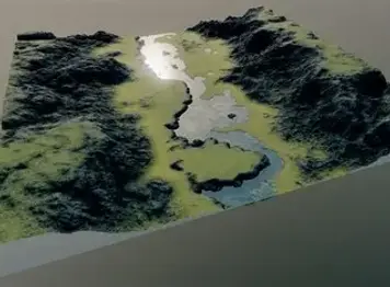
3D Terrain Model
"Visualize your land in full 3D. Slopes, elevations, and terrain features rendered with precision. Whether you're building a home, planning infrastructure, or designing a off grid retreat, 3d terrain models help you make smarter, faster, and safer decisions before breaking ground."

How Water Moves
Drainage Flow Analysis
"See exactly how water moves, pools, and drains on you land --prevent erosion and protect your site."
-
Generate centimeter‑accurate DSMs with the Matrice 4T and RTK
-
Extract contour lines and slope/aspect maps to show gradients.
-
Delineate watersheds and calculate flow‑accumulation paths.
-
Run hydrology simulations in DJI Terra to map runoff and pooling.
Actionable Sunlight Data
Sun/Shade Analysis
Get actionable sunlight data to position your home, panels, and plantings perfectly—saving you money on heating, cooling, and maintenance down the road.
-
Identify areas of consistent shade for seasonal crops.
-
Map peak sun hours across your property”
-
Unlock Your Land’s Light & Shadow Secrets”
-
Determine optimal solar panel or garden placement
Starting At 149$
Flexible Drone Mapping Packages
Every property is different. Get only what you need -- or bundle services for best value.
Best for Owners & Buyers
-
Orthomosiac Map -- Starting at $149
-
3D Terrain Model -- Staring at $159
-
Contour Mapping -- Starting at $129
-
Sun & Shade Analysis -- Starting at $99
-
Drainage Flow Map -- Starting at $149
-
Hard drive Copy -- $25 flat rate
Larger Acreage may increase final pricing. Quotes available.
Individual Services

Explore Our Other Services
Your land has layers -- Discover what else we can uncover.


