
Horizon Homestead Plan™
Precision 3D Mapping & Aerial Property Design

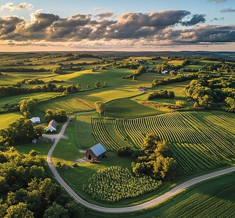
3D Mapping
Your Land, Mapped In 3D, Ready To Build!
3D Mapping & Site Planning for the Modern Homestead
Turn your land into a detailed 3D blueprint. Complete with custom layout designs, precise drainage modeling, and sun & shade analysis. So you can plan gardens, outbuildings, and water management with confidence. Reach out to see how your homestead can thrive tomorrow.
Mapping Variations
Visualize Your Land in Full, 3D Slopes

Orthomosaic Maps
Top-down, high-resolution stitched maps that capture every square foot of your property. Ideal for planning, real estate, and progress documentation.
.webp)
Contour Mapping
Understand how your land flows. Contour maps reveal elevation changes with precise lines, helping you plan grading, drainage, and building placement with confidence—ideal for construction, homesteading, and sustainable design.

3D Terrain Model
Visualize your land in full 3D. Slopes, elevations, and terrain features rendered with precision. Whether you're building a home, planning infrastructure, or designing an off-grid retreat, 3D terrain models help you make smarter, faster, and safer decisions before breaking ground.

How Water Moves
Drainage Flow Analysis
See exactly how water moves, pools, and drains on your land to prevent erosion and protect your site.
-
Generate centimeter accurate DSMs with the Matrice 4T and RTK.
-
Extract contour lines and slope/aspect maps to show gradients.
-
Delineate watersheds and calculate flow‑accumulation paths.
-
Run hydrology simulations to map runoff and pooling.
Actionable Sunlight Data
Sun & Shade Analysis
Get actionable sunlight data to position your home, panels, and plantings perfectly—saving you money on heating, cooling, and maintenance down the road.
-
Identify areas of consistent shade for seasonal crops.
-
Map peak sun hours across your property.
-
Unlock your land’s light and shadow patterns.
-
Determine optimal solar panel or garden placement.
Starting At $400 for up to 5 acres
+$30 per additional acre
Horizon Homestead Plan™
This is for landowners, homesteaders, off-grid planners, rural homeowners, and people planning driveways, gardens, drainage, fencing, solar, building sites, or land improvements.
Plan Features
-
RTK measurable orthophoto map
-
Terrain and slope map
-
Drainage & flow-path map
-
Seasonal sun and shade analysis
-
Practical land planning recommendations
-
Printable PDF deliverables
-
Shareable digital deliverables
-
Dropbox delivery
-
Optional KMZ/KML for Google Earth when useful

Explore Our Other Services
Your land has layers -- Discover what else we can uncover.


